
Ortho Mapping [ArcGIS Pro/Yuneec]
How to use the Ortho Mapping feature in ArcGIS Pro using Yuneec Typhoon H Pro CGO3+ images.
Problems:
– unknown camera parameters
– Ortho Mapping import errors (no valid elevation, bad metadata)
Solution:
- Get image series with GPS info from UAV camera
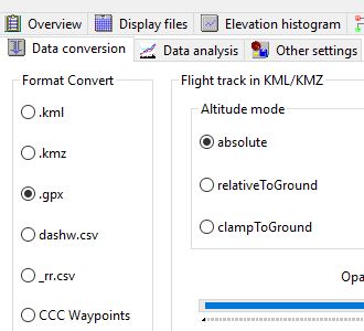
For Yuneec UAVs we use the Q500log2kml App (Settings->Data Conversion) to export the flight log as GPX with elevation above sea level.We need the elevation above sea level but Yuneec writes the relative elevation to the EXIF data of the images.
We can use Geosetter to update our EXIF data using our GPX export
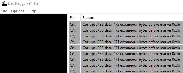
CGO3+ images have image metadata errors – use BadPeggy to test for such errors.
These images will cause errors in some applications! (ArcGIS Pro, Meshroom,…)
To fix this, use IrfranView batch conversion (File->Batch Conversion/Rename) without image compression. IrfranView will fix these problems.
2. Import the images in your project, Create new Ortho Mapping workspace
3. Add camera information as follows (or crate a .csv):
The Yuneec CGO3+ has a Sony IMX377EQH5 Sensor installed.
| ObjectID | CameraMaker | CameraModel | PixelSize | NCols | NRows | FocalLength | PrincipalX | PrincipalY | Konrady | Decentering |
| 1 | Yuneec | CGO3+ | 1.55 | 4000 | 3000 | 14000 | 0 | 0 | 0;0;0;0 | 0;0 |
4. continue the workflow as described in the ArcGIS Pro help.
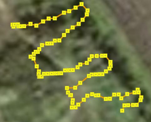
Now you can plot the flight path and compute DEMs and Ortho images
Q500log2kml App Links:
Q500log2kml Homepage: http://h-elsner.mooo.com/
Download Win: h-elsner.mooo.com/downloads/q500log2kml.zip
LINUX 64bit: h-elsner.mooo.com/downloads/q500log2kml.tar.gz
MAC OS X: h-elsner.mooo.com/downloads/q500log2kml_DE.dmg.zip
Manual: h-elsner.mooo.com/mydat/Q500log2kml.pdf